LONG DAY CIRCUIT TO THE SHORES OF ENIGMATIC LOCH LOCH

LONELY OASIS: Dropping down from the back of Carn nan Gabhar to reveal the hidden blue streak of Loch Loch

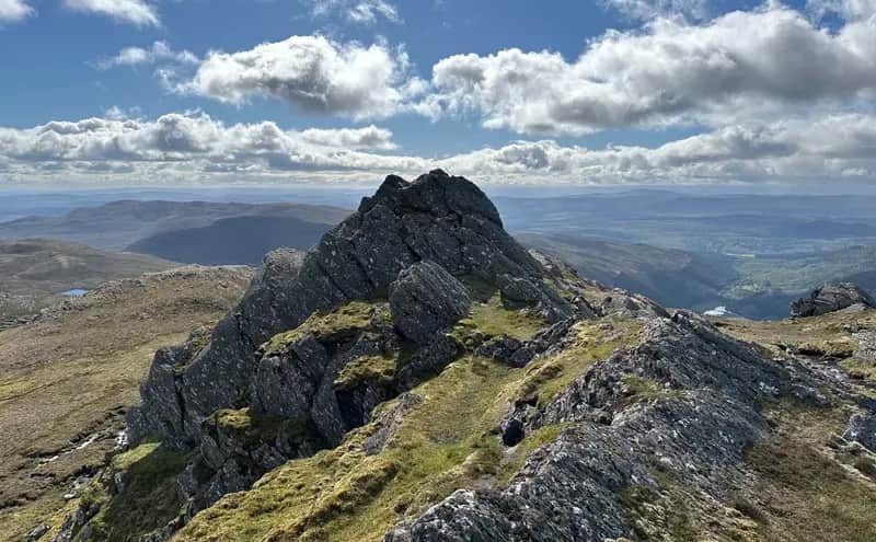
TRUE SUMMIT: Carn nan Gabhar
I'VE long been fascinated by Loch Loch, that beautiful hourglass body of water tucked away in the confines of lonely Glen Loch beneath the rolling eastern slopes of Beinn a' Ghlo.
Loch Loch: the repeat is enough to spark interest amongst even the mildly curious, but the remote and deserted glen in which it lies also has a long and turbulent history involving royal hunts and feasts on a massive scale, grisly murders and revenge killings.
The loch is only about two kilometres long, and around the midway point it narrows to such an extent that it appears to split in two with a shallow water passage that makes it possible to walk from one side to the other in just a dozen or so steps. That gap may even have been closer at one time, and the name likely derives from early maps that show it as two separate lochs simply marked 'Loch' and 'Loch'.
The other possibility is that the use of the word 'loch' in Gaelic can refer to dark or black, so Glen Loch would be the dark glen, and the loch therein the dark water of the dark glen. The fact that the hamlet to the south is Straloch – the 'dark strath or glen' – lends some credence to this theory. Or it could simply be that its beauty so captured the imagination of cartographers that they had to name it twice, long before anyone had thought about New York, New York.
Whatever your preference, there's no question it's a long day's outing to get there. I had been planning an expedition for nearly three years, but Covid restrictions and the lack of decent weather conditions kept pushing it back. Twice recently I had arrived at Loch Moraig but found Beinn a' Ghlo buried deep under a blanket of stubborn grey. The thought of taking on a 30-kilometre mountain circuit with no guarantee of views didn't appeal.
Third time lucky though, a forecast that even the pessimistic MWIS couldn't find fault with – wall-to-wall sunshine, a cooling breeze and clear skies – and I was off. My plan was to head into the heart of Beinn a' Ghlo, skirting the first two Munros and heading up on to Carn nan Gabhar, then continuing down its north ridge until I had outflanked the crags on the eastern faces before dropping down easy slopes just below Meall Gharran, the minor summit at the end of the ridge-line.
I had only traversed the mountain in a clockwise manner previously but I remembered only too well the squelch of the descent by the Allt Bealach an Fhiodha and the further deterioration of the intermittent path leading back to more solid ground. Seven years on, things had changed. There was now a new and well-engineered branch path rising between Beinn Bheag and the rocky prow of Airgiod Bheinn into the mouth of the corrie. It eventually faded into muddy familiarity, but at least it had reduced the bog-trot time by half.
There's no early reveal of the loch from the summit of Carn nan Gabhar, the steepness of the slopes and intervening bands of crags meaning it remains largely hidden from view until further round the twisting line of the ridge. The initial descent does, however, give fresh perspective of the vast bulk of Beinn a' Ghlo; the elongated backbone of Braigh Coire Chruinn-bhalgain running all the way north to the River Tilt, an almost mirror image for that of Carn na Gabhar, while only the pyramid tip of Carn Liath is visible, a now distant relation to its siblings.
Even the rock-framed aperture above Coire cas-eagallach fails to provide a line of sight to the loch, the eyes restricted to the south-east and the faint silver trails of the Allt Glen Loch disappearing over the horizon into Gleann Fearnach.
The first glimpse came after I had bypassed the rounded top of Meall a' Mhuirich and started dropping down heather-clad ground from the col before Meall Gharran, a blue ribbon off to my right, penned in between rough, sweeping slopes. The violin shape became more pronounced on descent, but at the same time, somewhat contrarily, the tight waistline seemed to shrink further until the two sides looked to be within touching distance.
The Lochain Burn spills north from the loch on its way to join the Tilt, and it can be problematic in spate but I had no such worries on my way across to pick up the path that runs along the eastern shore. Erosion has caused part of the banking to collapse, but the low water meant it was simple enough to boulder hop near the surface when required.
Considering the mountainous topography, there are some surprisingly flat and grassy stretches at the top of the glen, one of which was the venue for a lavish royal jamboree in 1529. In a display aimed at showing off his wealth and power, John, the Earl of Atholl, built a huge timber palace for hundreds of guests including King James V, his mother, Queen Margaret, and an ambassador of the Pope. They hunted and feasted for days, killing hundreds of deer and other animals, and, at the end of it all, they burned down the wooden castle. Even in these days, it seems, we had dirty campers.
Thirty years later, there was another major royal occasion in the glen when Mary, Queen of Scots, visited with her entourage and sat on a knoll at the southern end of the loch to watch the Earl and his hunters go about their business of corralling the deer herds for a mass slaughter.
The loch sits at the centre of an area that was known as the Seven Shielings, and it's difficult to equate the emptiness and remoteness of the glen today with that of 200 years ago when there were hundreds of people working and tending their livestock from this temporary summer base. As if life wasn't hard enough, the rules and time limits set by the lairds on access were stringent with the threat of expensive penalties for anyone who failed to adhere. Those who kept pigs seemed to be particularly unpopular with a raft of extra regulations applying.
Most of the settlements were on the eastern side of the loch but it's hard work trying to pinpoint the scant remains of buildings scattered amidst the boulder-strewn hillside of Creag an Loch. One of the biggest sites was Ruigh na Cuile (the shieling of the wind). Its inhabitants were caught in the middle of a fierce land dispute between the estates of Atholl and Lude which led to violence and legal battles for almost 30 years in the late 1600s. One shelter, the Lochain Bothy, was built and torn down on numerous occasions by rival militias. Many years later, it was burned down because it was believed to have become a base for poachers. This time, there was no resurrection.
Another unremarkable pile of stones further south above the shore is Comyn's Cairn, said to be the location of a famous act of revenge. The Comyns (later Cummings) were one of the dominant families in Scotland around the time of the Wars of Independence and controlled huge swathes of land in the north.
Their influence had waned by the 1400s but they still carried on bloody feuds with rival clans. In one particularly grisly incident, what started as a cattle raid ended with the Comyns slaughtering the MacIntosh family and seizing their possessions. Amid the carnage, a baby boy had survived. He was taken in by another family but wasn't told of his background until he reached 18.
Then, with revenge in mind, he gathered a group of heavily-armed men and ambushed his family's murderers. The head of the Comyn clan fled up the side of Loch Loch but as he stopped for a rest, he was killed by an arrow fired from the other side of the loch by his pursuer. The MacIntoshes later took more bloody retribution by slaughtering the Comyns after tricking them into attending a peace summit.
I reached the midway point of the loch where the water was trickling over a bed of stones. It was hardly enough to get the boots wet, so just to prove that this walking on water lark is no big deal, I strolled over the near-isthmus to the other side and then back again. Stop in the middle, look one way, and it's a loch. Turn around, and it's another loch. From certain angles, it's easy to see how one can become two. Besides, when it comes to naming conventions, most people would plump for the romantic.
A rim of white sand signalled the end of the loch and the glen started to widen, the looming triangle of the Corbett, Ben Vuirich, dead ahead. Somewhere off to the right, was another set of remains I wanted to visit, Leacainn Diollaidh, 'the saddle slope'.
This settlement was famed for a saddle-shaped stone which was alleged to aid fertility. It was said that any woman who was unable to conceive could sit on this stone, and from all the country they came, right up until the late 1800s. There were plenty of large stones piled amongst the heather, but none that I could see resembling a saddle. Probably as well – better not to take any chances at my age.
One monument that is hard to miss is the beehive memorial cairn to the RAF crew who died when their Hercules aircraft crashed here in 1993. Nearby lay a poppy wreath and another smaller cairn made up of stones and aircraft wreckage and holding a polished silver plaque, proof that some still make the pilgrimage to this remote site to pay their respects.
I made my way back to the track for the long march out. I passed the foot of Ben Vuirich and considered dropping offline again further on to visit Ruidh na H-Eilrig, another of the Seven Shielings, which sits in the shadow of the long wall of Airgiod Bheinn and Carn nan Gabhar, but the thought of trudging over more rough ground with such a long trek ahead persuaded me otherwise.
Elrig refers to a deer enclosure or hide, walled on three sides and usually found on rising ground in an open area alongside water where hunters could sit and wait for the deer to be driven towards them before they unleashed their hounds.
Loch Loch was no longer visible, only the pale, twisting stripe of the track disappearing over every horizon, a seemingly endless return involving an indecent amount of ascent for tired feet and last legs at this stage of the day. I envied the cyclists freewheeling in the opposite direction, heading for the downhill of Gleann Fearnach.
It was almost enough to make me want to head back to the loch and sit with my feet dangling into the water. Almost.