COLBY CAMPS AND SCOTLAND'S MOUNTAIN MAPPING PIONEERS

ROCKS OF AGES; Looking through the morning sky from the huge circular cairn on Mam Sodhail to neighbouring Carn Eige

REMAINS; Creach Bheinn camp
THE massive cairn which crowns Mam Sodhail is an instantly recognisable summit marker, standing out on the skyline like an ancient fortress.
Yet this huge circular stone structure was once much higher: when constructed by an Ordnance Survey team in 1848 to surround a trig pillar, it stood 23 feet high with a base circumstance of 60 feet. There are also the remains of a smaller shelter just below the summit.
The team spent three days on the mountain as part of an extensive survey and measurement programme – The Trigonometrical Survey of Scotland – which started in the first decade of the 19thCentury and wasn't completed until 1852.
Three days was a good result. The nature of the instruments of that time, the need for constant checking and re-checking to obtain precise measurements and the unpredictability of the Scottish climate often meant lengthy stays at high altitude of up to three months to get the work completed. This meant setting up temporary camps, the leftovers of which can be found throughout the hills.
These camps became known as Colby Camps, after Major General Thomas Colby, director of the Ordnance Survey from 1820 to 1846 and commander of the Royal Engineers survey teams.
Remains from these expeditions range from huge walled structures like those on Mam Sodhail and Creach Bheinn, to small, tumbled-down shelters and stone circles, the walls built as windbreaks, the circles a protection foundation for tents. Where there was a lack of stone, some would have comprised of turf. The more elaborate shelters hinted at longer occupations due to poor weather.
There is no comprehensive record of the number or location of Colby Camps, but it's likely there would be more than the visible remains suggest with some form of shelter erected at every occupied trigonometrical station.
Although Colby is a name most remember, it was a Scot, General William Roy, born near Carluke, who is regarded as the father of Ordnance Survey, having carried out the first British-based survey in 1784 on Hounslow Heath.
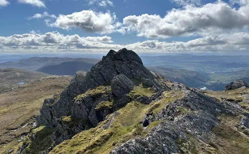
Many years ago at the beginning of my Corbetts round, I remember being intrigued and excited at a suggestion that the summit of Creach Bheinn may have housed a look-out station during the Napoleonic Wars. The OS map draws attention to a camp on the top of this mountain and there are two huge walls of granite blocks and several circles.
It didn't appear too far-fetched: the reference was in a reputable guide book to the Corbetts, and the peninsulas of Ardgour, Morvern and Sunart were important during the conflict. In the early part of the 19th Century lead from the mines at Strontian was used to manufacture bullets, and part of the workforce was made up of captured forces from Napoleon's army. Creach Bheinn also gives expansive views down the length of Loch Linnhe, a perfect watchtower for spotting enemy ships trying to launch an invasion or sneak attack.
However, much as the romantic in me would like this to be the case, it's more probable this was a Colby Camp. Three of the tent circles lie close together, the fourth is further away and is likely to have been an officer's billet. There is also a small stone shelter, and there would have been roofed buildings that would have housed the guard and cook-house.
The locations of the camps are widely spread. There are other substantial remains on Jura – on the summit area of Beinn an Oir – and on Ben Alder and Ben Macdui (The Sappers' Bothy), and the massive summit cairn on An Cliseam in Harris is testament to the work of the OS teams. There is a prominent stone shelter and windbreak on Ben Klibreck, and ruins can also be found not far from the summit of Corryhabbie Hill in Morayshire, where the trig point is crowned by a curious pointed metal cap.
Although Colby's active participation became limited in the later years of the project, he was known to have been on Ben Hutig in Sutherland – the site of the controversial planned spaceport – in 1938.
The distances covered by the teams over tough terrain were remarkable. One expedition walked 513 miles in just 22 days through Inverness-shire, Ross-shire, Caithness and Orkney, then embarked on a 39-mile mountainous day yomp from Grantown to Aviemore before continuing on to Corryhabbie Hill, a total of 586 miles.
Their only failure came in Skye where the weather continually thwarted their attempts. There are many who have followed in their footsteps since who know that feeling. It's thought they were defeated by the rock sentinel known as the Gendarme – which collapsed with a loud crash in 1987 – during an ascent of the west ridge of Sgurr nan Gillean.
The re-triangulation of Britain, on which modern mapping is based, began 83 years later in 1935, and was completed in 1962. This provided the backbone of the system that has served until recent advances in satellite and electronic distance measurement.
What is left of the camps is a reminder of the pioneers who set us on this path.